


7.3 km | 10.8 km-effort
![Trail On foot Ústí nad Orlicí - [M] Česká Třebová-Ústí nad Orlicí - Photo](https://media.geolcdn.com/t/1900/400/bcfb6775-14af-4fbf-9860-41cde003e421.jpeg&format=pjpeg&maxdim=2)

Tous les sentiers balisés d’Europe GUIDE+


FREE GPS app for hiking
 SityTrail
IGN / Geographical institutes
SityTrail World
The world is yours!
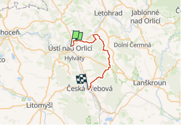
Trail On foot of 25 km to be discovered at Northeast, Pardubický kraj, Ústí nad Orlicí. This trail is proposed by SityTrail - itinéraires balisés pédestres.
Trail created by cz:KČT.
Hotové z Ústí nad Orlicí po Horákovou kapli
![Trail On foot Ústí nad Orlicí - [M] Česká Třebová-Ústí nad Orlicí - Photo 1](https://media.geolcdn.com/t/2048/auto/e83a9ec9-8390-45e2-a995-1f49ae0b4fac.jpeg&format=jpg&maxdim=0 "Trail On foot Ústí nad Orlicí - [M] Česká Třebová-Ústí nad Orlicí - Photo 1")
![Trail On foot Ústí nad Orlicí - [M] Česká Třebová-Ústí nad Orlicí - Photo 2](https://media.geolcdn.com/t/2048/auto/c07f5074-5bc1-4b24-9226-e534622657bf.jpeg&format=jpg&maxdim=0 "Trail On foot Ústí nad Orlicí - [M] Česká Třebová-Ústí nad Orlicí - Photo 2")
![Trail On foot Ústí nad Orlicí - [M] Česká Třebová-Ústí nad Orlicí - Photo 3](https://media.geolcdn.com/t/2048/auto/0cb429ea-6f9e-43c6-8481-5d91cd49a074.jpeg&format=jpg&maxdim=0 "Trail On foot Ústí nad Orlicí - [M] Česká Třebová-Ústí nad Orlicí - Photo 3")
![Trail On foot Ústí nad Orlicí - [M] Česká Třebová-Ústí nad Orlicí - Photo 4](https://media.geolcdn.com/t/2048/auto/304aef12-1b0e-4511-9b29-9666e88eb97b.jpeg&format=jpg&maxdim=0 "Trail On foot Ústí nad Orlicí - [M] Česká Třebová-Ústí nad Orlicí - Photo 4")
![Trail On foot Ústí nad Orlicí - [M] Česká Třebová-Ústí nad Orlicí - Photo 5](https://media.geolcdn.com/t/2048/auto/fb40ce17-ee77-4779-9aa3-fab1f6c5d047.jpeg&format=jpg&maxdim=0 "Trail On foot Ústí nad Orlicí - [M] Česká Třebová-Ústí nad Orlicí - Photo 5")
![Trail On foot Ústí nad Orlicí - [M] Česká Třebová-Ústí nad Orlicí - Photo 6](https://media.geolcdn.com/t/2048/auto/6da183c3-4e7d-45df-9e2c-9ba0b56523bf.jpeg&format=jpg&maxdim=0 "Trail On foot Ústí nad Orlicí - [M] Česká Třebová-Ústí nad Orlicí - Photo 6")
![Trail On foot Ústí nad Orlicí - [M] Česká Třebová-Ústí nad Orlicí - Photo 7](https://media.geolcdn.com/t/2048/auto/17fcb35f-20f6-4db7-9f6b-6849f3af9742.jpeg&format=jpg&maxdim=0 "Trail On foot Ústí nad Orlicí - [M] Česká Třebová-Ústí nad Orlicí - Photo 7")
![Trail On foot Ústí nad Orlicí - [M] Česká Třebová-Ústí nad Orlicí - Photo 8](https://media.geolcdn.com/t/2048/auto/7c326044-febf-4739-abed-c1755eebb298.jpeg&format=jpg&maxdim=0 "Trail On foot Ústí nad Orlicí - [M] Česká Třebová-Ústí nad Orlicí - Photo 8")
![Trail On foot Ústí nad Orlicí - [M] Česká Třebová-Ústí nad Orlicí - Photo 9](https://media.geolcdn.com/t/2048/auto/d49537b4-2c98-4f0a-822a-9b0a3371ae0e.jpeg&format=jpg&maxdim=0 "Trail On foot Ústí nad Orlicí - [M] Česká Třebová-Ústí nad Orlicí - Photo 9")
![Trail On foot Ústí nad Orlicí - [M] Česká Třebová-Ústí nad Orlicí - Photo 10](https://media.geolcdn.com/t/2048/auto/bcfb6775-14af-4fbf-9860-41cde003e421.jpeg&format=jpg&maxdim=0 "Trail On foot Ústí nad Orlicí - [M] Česká Třebová-Ústí nad Orlicí - Photo 10")
On foot
On foot
On foot